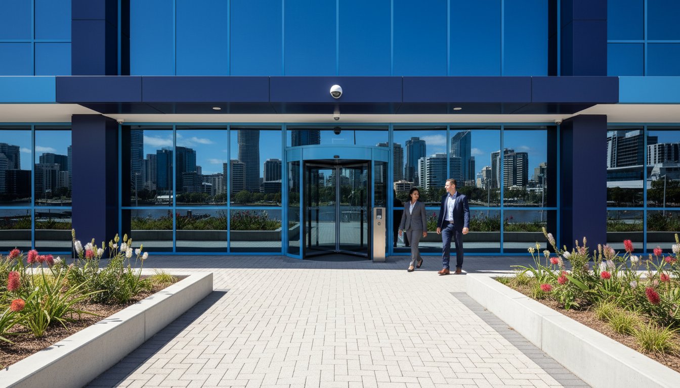
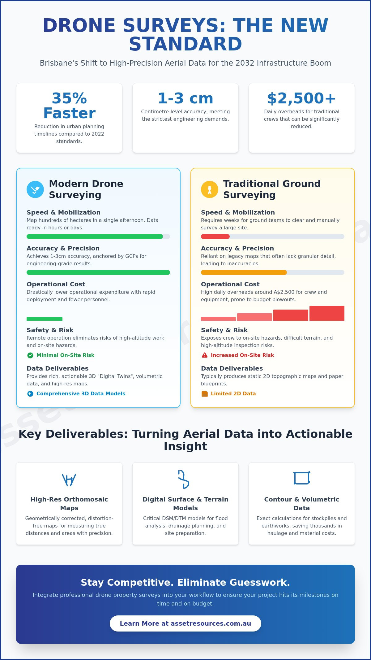
By 2026, a traditional surveying crew on a high-density Brisbane site will be as rare as a paper blueprint. As South East Queensland accelerates its infrastructure pipeline ahead of the 2032 Games, developers can’t afford the A$2,500 daily overheads or the safety risks associated with manual high-altitude inspections. Integrating a professional drone property survey into your workflow is no longer a luxury; it’s a pragmatic necessity for staying competitive in a market that demands centimetre-level precision and rapid mobilization.
We understand that you’re likely frustrated by slow turnaround times and the inaccuracy of legacy topographic maps that frequently stall your project timelines. This guide explains how drone property surveys are transforming Brisbane’s industrial landscape by providing high-precision data and significantly reducing operational costs. You’ll learn about the latest 3D modeling capabilities, safety-first inspection protocols, and the specific ways these aerial assets ensure your project hits its milestones without the usual site hazards or budget blowouts.
Key Takeaways
- Understand the shift toward 3D geospatial data models and how high-speed land intelligence is redefining Brisbane’s development landscape.
- Identify the technical edge provided by LiDAR and photogrammetry payloads when converting aerial imagery into actionable project data.
- Calculate the operational ROI of a drone property survey by comparing rapid site mobilization and data turnaround against conventional ground methods.
- Explore practical applications for construction and real estate, from automated stockpile calculations to high-impact 3D marketing assets.
- Master the compliance landscape by understanding CASA regulations and the insurance standards required for safe UAV operations in urban environments.
What is a Drone Property Survey? Modern Land Intelligence in Brisbane
A drone property survey is a high-speed data collection method that utilizes Unmanned Aerial Vehicles (UAVs) to capture precise, actionable site information. By 2026, the Brisbane development sector has moved beyond simple 2D aerial photography. We now utilize advanced 3D geospatial data models to inform every stage of the project lifecycle. This shift utilizes modern aerial survey technology to provide a level of site intelligence that was previously cost-prohibitive for mid-sized civil projects.
South East Queensland is currently managing a $19 billion infrastructure pipeline ahead of the 2032 Games. This volume of work requires rapid mobilization and absolute accuracy. Drones deliver both. Instead of waiting weeks for traditional ground teams to clear a site, developers use UAVs to map hundreds of hectares in a single afternoon. It’s about reducing risk. By creating “digital twins”—exact virtual replicas of a physical site—project managers can simulate earthworks and drainage before a single machine arrives on-site. This pragmatism ensures that human and capital assets are deployed where they’re needed most.
The Evolution of Aerial Mapping in QLD
Brisbane’s development history relied on manned aircraft and coarse satellite imagery that often lacked the resolution for granular planning. By 2026, localized UAV precision has changed the game, offering accuracy within 1 to 3 centimeters. Brisbane developers now use these surveys for pre-purchase site due diligence to identify hidden topography issues that could blow out budgets. This technology has shortened urban planning timelines by approximately 35% compared to 2022 standards. It’s a no-nonsense approach to site assessment that prioritizes speed without sacrificing safety or quality.
Key Deliverables: What You Get From a Survey
A professional drone property survey provides a comprehensive data package that integrates directly into BIM (Building Information Modeling) software. These outputs are essential for compliance and precision engineering. Key deliverables include:
- High-resolution orthomosaic maps: These are thousands of individual images stitched together and geometrically corrected to remove distortion, creating a map that’s accurate for measuring true distances.
- Digital Surface Models (DSM) and Digital Terrain Models (DTM): These models distinguish between natural ground levels and man-made structures, which is critical for flood modeling in Brisbane’s river-adjacent suburbs.
- Contour maps and volumetric data: We provide exact calculations for stockpiles and excavation pits. Knowing you need to move 4,500 cubic meters of soil rather than a “rough estimate” saves thousands in haulage costs.
Data drives decisions on the modern worksite. By integrating UAV intelligence, Queensland firms ensure their projects are built on a foundation of facts, not assumptions. This is how we maintain the integrity of the Brisbane skyline while keeping projects on schedule and under budget.
The Technology Behind the Flight: From Photogrammetry to LiDAR
A modern drone property survey isn’t just a collection of aerial photos; it’s a sophisticated data acquisition exercise. Drones fly pre-programmed grids, capturing hundreds of high-resolution images with significant overlap. Specialized software then uses these images to triangulate millions of data points. By 2026, the industry has shifted away from simple visual inspections toward centimetre-level accuracy as the baseline for Brisbane construction and civil works. This precision relies heavily on Ground Control Points (GCPs). These are physical markers on the ground with known coordinates that anchor the digital model to the real world, ensuring the survey integrity meets strict engineering standards.
The choice of payload determines the quality of the output. While standard RGB sensors provide excellent visual clarity for progress reports, professional-grade surveys often require specialized sensors to meet engineering tolerances. High-frequency data collection ensures that project managers can identify site deviations before they become costly errors. Using these advanced tools allows for a level of site transparency that was impossible only a few years ago.
Photogrammetry vs. LiDAR: Choosing the Right Sensor
Photogrammetry works by stitching photos together to create 2D orthomosaics and 3D models. It’s the go-to for visual site records and detailed surface modeling. However, when dealing with the dense vegetation common in South East Queensland, LiDAR (Light Detection and Ranging) becomes essential. LiDAR pulses laser beams that can penetrate tree canopies to map the actual ground surface. For a deep dive into technical specifications, see our LiDAR drone technology guide. This Comparative Study of Lidar and Photogrammetry highlights how each method serves different topographical needs depending on the site’s complexity and the required vertical accuracy.
Thermal Imaging for Asset Protection
Thermal sensors add another layer to the drone property survey by detecting heat signatures invisible to the naked eye. In Brisbane’s industrial hubs, we use this for high-precision roof inspections to spot moisture ingress or insulation failures. Beyond maintenance, thermal data identifies security vulnerabilities by monitoring heat signatures across large perimeters at night. This data integrates seamlessly with CCTV installation Brisbane services to create a comprehensive site awareness net. It’s about protecting your physical assets through proactive, data-driven oversight that works 24/7.
If you’re ready to improve your site’s precision and safety, contact our expert team to discuss a tailored survey plan for your next project.
Drone vs. Traditional Ground Surveys: Calculating the ROI
For a standard 10-hectare development site in Brisbane, the efficiency gap between old and new methods is undeniable. A traditional ground crew typically requires two to three full days to map this area using total stations. In contrast, a modern drone property survey captures the same footprint in under 30 minutes of flight time. This isn’t just about speed; it’s about the volume of intelligence gathered. While a surveyor on foot might capture 500 discrete points, a UAV generates a point cloud with over 50 million data points, creating a high-resolution digital twin of the asset.
Safety is a non-negotiable priority in the resource and construction sectors. Drones eliminate the need for personnel to navigate unstable stockpiles, steep embankments, or active heavy machinery zones. By adhering to CASA drone rules, operators ensure site compliance while keeping boots on the ground out of harm’s way. This reduction in risk exposure directly lowers insurance premiums and minimizes potential project downtime. The initial mobilization cost of a drone team is often offset by the massive reduction in man-hours and the elimination of specialized access equipment like cherry pickers or scaffolding.
Time-to-Data: The 2026 Speed Advantage
By 2026, the bottleneck isn’t the flight; it’s the data turnaround. Brisbane developers now utilize edge computing to process photogrammetry in real-time. Stakeholders receive 3D models via cloud platforms before the pilot has even left the site. On a 2025 Gold Coast high-rise project, weekly drone flights provided 4D progress tracking for a 45-story residential tower. This allowed project managers to identify a 12% deviation in material placement within hours, preventing a rework cost estimated at A$85,000.
Accuracy and Precision Standards
Precision in a drone property survey is measured by Ground Sample Distance (GSD). In 2026, commercial sensors achieve a GSD of less than 1 centimetre per pixel. This level of detail is sufficient for volumetric calculations and contour mapping. However, drones don’t replace humans entirely. Cadastral surveys for legal property boundaries still require traditional ground-based verification to meet Queensland’s regulatory standards. The most effective projects use a hybrid approach:
- UAV Capture: Rapidly gathers mass data and topographical features across the entire site.
- Ground Control Points (GCPs): Established by surveyors to anchor the drone data to the physical earth with millimetre precision.
- Verification: High-risk structural points are checked manually to ensure 100% compliance with engineering specs.
This partnership between tech and trade ensures that speed never compromises structural integrity. It’s a pragmatic solution that treats data as a high-value asset, ensuring every project begins on a foundation of absolute certainty.
Industry Applications: Construction, Real Estate, and Asset Security
By 2026, the utility of a drone property survey has expanded far beyond simple photography. It’s now a core component of risk management and operational efficiency across South East Queensland. In the construction sector, project managers use high-resolution data to track progress against digital twins in real time. Real estate agencies have shifted toward immersive 3D walkthroughs that allow international buyers to inspect Brisbane developments without leaving their home country. For infrastructure, drones eliminate the need for costly scaffolding when inspecting bridges or telecommunications towers, which reduces safety risks by approximately 35% compared to manual methods. Security is another critical area. Site managers rely on aerial mapping to identify blind spots and vulnerabilities. This data allows security firms Brisbane developers trust to deploy personnel and technology with surgical precision.
Construction Progress Monitoring
Weekly drone flyovers provide a verifiable visual record that keeps projects on track. These surveys allow for “as-built” versus “as-designed” comparisons. This helps identify structural deviations before they become expensive mistakes. Site supervisors use this data to minimize disputes with contractors by providing clear evidence of site activity on specific dates. For earthmoving operations, drones provide precise volumetric calculations. Instead of relying on manual estimates, teams get exact data on stockpile sizes and excavation depths. This level of accuracy can save a medium-sized civil project upwards of A$15,000 in monthly surveying costs alone.
Large-Scale Asset and Facility Management
Asset management in 2026 requires a “boots on the ground” pragmatism combined with high-tech oversight. Drones allow for rapid inspection of commercial rooftops to check solar panel efficiency or storm damage without putting workers at height. In industrial zones, aerial mapping is the first step in designing robust access control systems and perimeter fencing. This is especially vital for remote QLD sites where mobilization costs are high. A single drone property survey can capture the entire layout of a mine site or regional facility. It ensures every asset is accounted for and secured. Beyond urban and industrial applications, primary producers across South East Queensland are leveraging farm mapping Brisbane techniques to harden property perimeters and eliminate costly blind spots across large rural landholdings. This proactive approach prevents unauthorized access and streamlines the maintenance of critical infrastructure across the state. For residential and commercial property owners in suburbs like Inala, Acacia Ridge, and Sunnybank, combining aerial site intelligence with a professional security camera installation Brisbane Southside solution ensures that every identified vulnerability is covered by a compliant, high-definition surveillance system.
Compliance and Selection: Hiring a Professional Drone Service
Selecting a partner for a drone property survey requires more than just looking at a portfolio of high-resolution images. In the high-stakes environment of Brisbane development, compliance is the foundation of every flight. The Civil Aviation Safety Authority (CASA) maintains strict oversight of commercial unmanned aerial vehicle (UAV) operations. Any provider you engage must hold a Remote Operator’s Certificate (ReOC). This document ensures the business has the necessary manuals, safety structures, and insurance to operate legally. Individual pilots must also carry a Remote Pilot License (RePL) for any craft weighing more than 2kg used for commercial purposes.
Insurance is a non-negotiable factor for urban projects. Standard public liability policies often exclude aviation activities, so you must verify that your provider carries specific UAV liability insurance. For Tier 1 construction sites or large-scale civil works in the Brisbane CBD, a minimum of A$20 million in public liability coverage is the industry benchmark. This protects your project from the financial risks associated with equipment failure or accidental damage in densely populated areas.
Navigating CASA Rules in Brisbane City
Brisbane presents a complex airspace environment. Significant portions of the city fall within controlled airspace due to the proximity of Brisbane International Airport and Archerfield Airport. Operating a drone property survey within 5.5 kilometres of these hubs requires specific CASA approvals and constant communication with Air Traffic Control. By 2026, the integration of Beyond Visual Line of Sight (BVLOS) permits and advanced night flying approvals will be standard for professional outfits. These certifications allow for more comprehensive site mapping without the pilot needing a direct line to the craft, provided the operator has the technical infrastructure to manage the risk.
Why Asset Resources Group for UAV Inspections?
Asset Resources Group brings a “boots on the ground” perspective to aerial intelligence. We don’t just fly drones; we integrate high-level data capture with our core expertise in physical security and industrial mobilization. Our safety-first approach means every flight plan undergoes a rigorous risk assessment before the propellers spin. We treat your property data as a critical business asset, utilizing encrypted storage and streamlined management systems to ensure your site intelligence remains secure and accessible. We understand the local Brisbane landscape, from council planning requirements to the specific wind patterns of the Riverside corridor, ensuring your data is accurate and compliant.
Before booking your next survey, ask these four critical questions:
- Can you provide a copy of your ReOC and current UAV-specific insurance certificate?
- How do you manage flight approvals for sites within Brisbane’s controlled airspace zones?
- What is your protocol for data redundancy and secure asset storage?
- Do your pilots have experience operating under BVLOS or night-flying permits for 24/7 project monitoring?
Secure Your Competitive Edge in Brisbane Development
Brisbane’s infrastructure pipeline is accelerating toward 2026. Relying on outdated manual methods slows down site mobilization and increases project overheads. A professional drone property survey provides the high-definition LiDAR and photogrammetry data required to keep complex civil projects on schedule. These aerial solutions offer a 400% increase in data point density over traditional ground methods; this ensures your site plans are built on absolute precision from day one. Compliance remains the backbone of any successful build. As South East Queensland local experts, we understand the specific terrain and regulatory hurdles unique to our region. Asset Resources combines CASA licensed operators with our background as integrated security and asset specialists to deliver results that prioritize both safety and quality. We’re ready to help you manage your land assets with the pragmatism and technical expertise your project deserves. Our team handles the technical heavy lifting so you can focus on delivery.
Get a Precision Drone Survey Quote for Your Brisbane Project
The right data makes all the difference when the stakes are high and deadlines are tight.
Frequently Asked Questions
Do I need a permit for a drone property survey in Brisbane?
You need a Remotely Piloted Aircraft Operator’s Certificate (ReOC) or must operate under the CASA “excluded” category for any commercial drone property survey in Brisbane. CASA regulations require all operators to register drones weighing more than 250 grams and follow standard operating conditions. In restricted Brisbane airspace, such as zones near Brisbane Airport, pilots must obtain digital flight authorization through the CASA RPAS Platform before takeoff.
How accurate is a drone survey compared to a traditional land survey?
Modern drone surveys achieve a horizontal accuracy of 20mm to 30mm when using Real-Time Kinematic (RTK) technology. While traditional total station surveys can reach sub-centimetre precision, drones capture millions of data points instead of hundreds. This density provides a more comprehensive digital twin for Brisbane construction sites. Licensed surveyors still verify critical boundary markers to meet Queensland state standards and ensure project compliance.
What is the cost of a drone property survey for a commercial site?
Market data from 2024 indicates a commercial drone property survey typically costs between A$1,500 and A$4,500 depending on the specific site complexity and required data outputs. High-resolution mapping for a 10-hectare industrial site often falls in the middle of this price range. These figures reflect the costs of CASA-certified pilots and the specialized software processing required to generate actionable engineering data for Queensland developers.
Can drones perform surveys in bad weather or high winds?
Drones can’t operate in heavy rain or winds exceeding 35 kilometres per hour without risking data quality and flight safety. High winds cause sensor instability which degrades the accuracy of photogrammetry or LiDAR results. Most Brisbane operators schedule flights for early mornings when thermal turbulence is low. This ensures the equipment stays within manufacturer-specified operating limits for wind resistance and moisture protection.
What file formats are delivered after a drone survey?
Standard deliverables include .TIFF files for orthomosaic maps and .LAS or .LAZ files for 3D point clouds. For integration into CAD software, providers supply .DXF or .DWG files that represent contour lines and site features. These formats allow Brisbane project managers to import survey data directly into BIM workflows. It ensures 100% compatibility with existing architectural and engineering software suites used in the Australian construction sector.
How long does it take to get the results of an aerial survey?
You’ll typically receive processed data within 24 to 72 hours after the flight is completed. While the flight for a 5-hectare Brisbane site might only take 45 minutes, processing thousands of images into a 3D model requires significant computing power. Complex LiDAR datasets or detailed volumetric analysis for civil works might extend this timeline to 5 business days depending on the required precision level.
Is drone surveying better than satellite imagery for land mapping?
Drone surveys offer a resolution of 1cm to 5cm per pixel, which is significantly better than the 30cm to 50cm per pixel provided by commercial satellites. This level of detail is necessary for identifying small site features like utility pits or curb heights on Brisbane developments. Drones also bypass cloud cover issues that frequently obscure satellite views, providing reliable on-demand data for active construction schedules.
Can drones see through trees to map the ground below?
Drones equipped with LiDAR sensors can penetrate dense vegetation to map the terrain below. These sensors emit up to 600,000 laser pulses per second, and many pulses find gaps between leaves to hit the ground. This technology allows Brisbane developers to create accurate farm mapping Brisbane and digital terrain models (DTM) for heavily wooded sites without the need for manual clearing or expensive ground-based crews.