Sending a worker up a scaffold or into a confined space just to check a weld isn’t just inefficient; it’s a safety risk that modern Queensland worksites can no longer justify. Safe Work Australia data shows that falls from height accounted for 11% of workplace fatalities in 2022, making remote inspections a logical priority for any safety-first operation. Whether you’re managing a civil project in Ipswich or a port facility in Brisbane, the traditional approach to monitoring large perimeters often results in high manual labor costs. Integrating an unmanned aerial vehicle into your operational toolkit changes this dynamic immediately. By shifting from manual oversight to aerial intelligence, industries across South East Queensland are achieving faster mobilization and more reliable data collection.
You likely already know that keeping your people safe while maintaining asset integrity is the highest priority on any site. This guide will show you exactly how industrial UAV technology is transforming asset protection and site inspections across Brisbane. We’ll examine the specific ROI of switching to professional-grade systems, explain the critical differences between a hobbyist drone and an industrial unmanned aerial vehicle, and provide a clear path through local CASA compliance requirements to ensure your operations remain above board.
Key Takeaways
- Master the terminology used in the Australian industrial sector and see how centimetre-level GPS accuracy is delivering pragmatic results for Brisbane projects.
- Discover how to enhance your security strategy by integrating aerial surveillance with local CCTV systems for a complete view of your South East Queensland assets.
- Navigate CASA compliance with ease by learning the operational differences between the “Excluded Category” and holding a professional Remote Operator Certificate (ReOC).
- Learn how deploying an unmanned aerial vehicle allows your team to transition from reactive repairs to a proactive, safety-first maintenance model.
- Identify the sensor technologies that turn raw aerial footage into high-value intelligence for protecting critical infrastructure and industrial sites.
What is an Unmanned Aerial Vehicle (UAV)? Defining the Tech
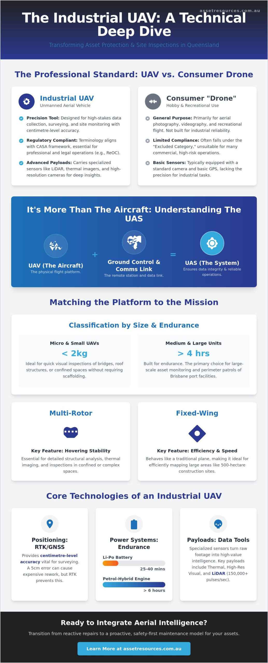
An Unmanned Aerial Vehicle (UAV) is an aircraft that operates without a human pilot on board, functioning through either remote control or pre-programmed autonomous flight paths. While the general public uses the term “drone” to describe everything from backyard toys to military hardware, Brisbane’s industrial sectors require more precise terminology. In professional environments, “unmanned aerial vehicle” is the standard because it identifies the specific flight platform used for high-stakes data collection and site monitoring.
The technology has evolved rapidly since the Civil Aviation Safety Authority (CASA) established the world’s first drone regulations in 2002. What began as specialized military equipment has transformed into a pragmatic commercial tool for South East Queensland’s construction, mining, and civil sectors. Professionals prefer the term UAV because it aligns with the regulatory framework required for compliance and safety. Using an unmanned aerial vehicle on a Brisbane job site isn’t about the novelty of flight; it’s about mobilizing a sophisticated asset to deliver measurable results in survey accuracy and risk reduction.
UAV vs. UAS: Understanding the System
A UAV refers strictly to the aircraft itself. However, for industrial operations to be successful, we must look at the Unmanned Aircraft System (UAS). This system encompasses the vehicle, the ground control station, and the communication link that binds them. For a project manager in Brisbane, the “system” is what ensures data integrity. Without a secure, low-latency communication link, the high-resolution imagery captured during a site audit cannot be safely transmitted or stored. This holistic view of the system ensures that every flight is a reliable, repeatable process rather than a one-off event.
Classification by Size and Capability
Choosing the right equipment depends on the specific requirements of the South East Queensland site. UAVs are categorized to match the scale of the task at hand:
- Micro and Small UAVs: Units weighing under 2kg are perfect for quick visual inspections. They allow teams to inspect bridge pylons or roof structures without the need for scaffolding.
- Medium and Large Units: These platforms are built for endurance, with some models capable of staying airborne for over 4 hours. They are the primary choice for Brisbane perimeter patrols and large-scale asset monitoring.
- Fixed-wing vs. Multi-rotor: Fixed-wing aircraft behave like traditional planes and are ideal for mapping 500-hectare sites efficiently. Multi-rotor units provide the hovering stability needed for detailed structural analysis and thermal imaging in tight spaces.
Selecting the correct unmanned aerial vehicle configuration ensures that the mobilization of technology matches the technical demands of the project, keeping operations on schedule and within budget.
The Technology Powering Modern Industrial UAVs
Modern industrial units have moved far beyond the capabilities of consumer drones. An unmanned aerial vehicle used in Brisbane today relies on a suite of hardware designed for precision, safety, and data integrity. High-precision GPS and GNSS modules now provide centimetre-level positioning through Real-Time Kinematic (RTK) technology. This level of accuracy is vital for surveying 50-hectare construction sites in South East Queensland where a 5cm error can lead to expensive rework and project delays.
Power systems determine the operational footprint of these machines. Standard lithium-polymer batteries typically offer 25 to 40 minutes of flight time. For remote QLD mining sites or vast agricultural holdings, petrol-hybrid engines are becoming the standard. These systems extend endurance to over 6 hours; this allows for long-corridor inspections of power lines or pipelines without the need for constant landings to swap batteries. It’s about maintaining momentum on-site.
Payloads: The “Business End” of the UAV
The payload defines the mission’s value. While cameras were the original focus, modern sensors provide deeper insights into asset health. Modern industrial payloads include:
- LiDAR sensors: These fire up to 150,000 laser pulses per second to create high-density 3D terrain models, even through dense scrub or forest canopy.
- Thermal imaging: Radiometric sensors detect minute heat variations. This identifies failing electrical insulators or structural security breaches at 02:00 AM.
- High-definition optical zoom: 30x or 40x optical zoom allows inspectors to identify hairline cracks on a bridge pylon or a rusted bolt on a communication tower from a safe distance of 50 metres.
Navigation and Control Systems
Control has shifted from manual stick-and-rudder piloting to intelligent autonomy. AI-driven obstacle avoidance uses binocular vision and infrared sensors to stop the aircraft before it contacts a crane or power line. While many industrial missions remain Remotely Piloted Aircraft (RPA) operations, there’s a significant move toward fully autonomous mission profiles. Every flight must strictly adhere to Australian UAV Regulations to ensure compliance and public safety.
Data security is a priority for corporate operations. AES-256 bit encryption now protects the link between the ground station and the unmanned aerial vehicle, preventing unauthorized data interception. Real-time telemetry feeds live flight data and sensor outputs directly to Brisbane site managers. This allows for immediate, data-backed decisions without waiting for the aircraft to land. If your project requires this level of technical expertise, sourcing qualified technical personnel ensures your fleet is operated with professional precision.
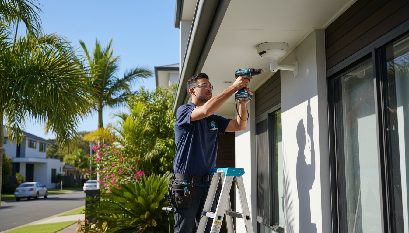
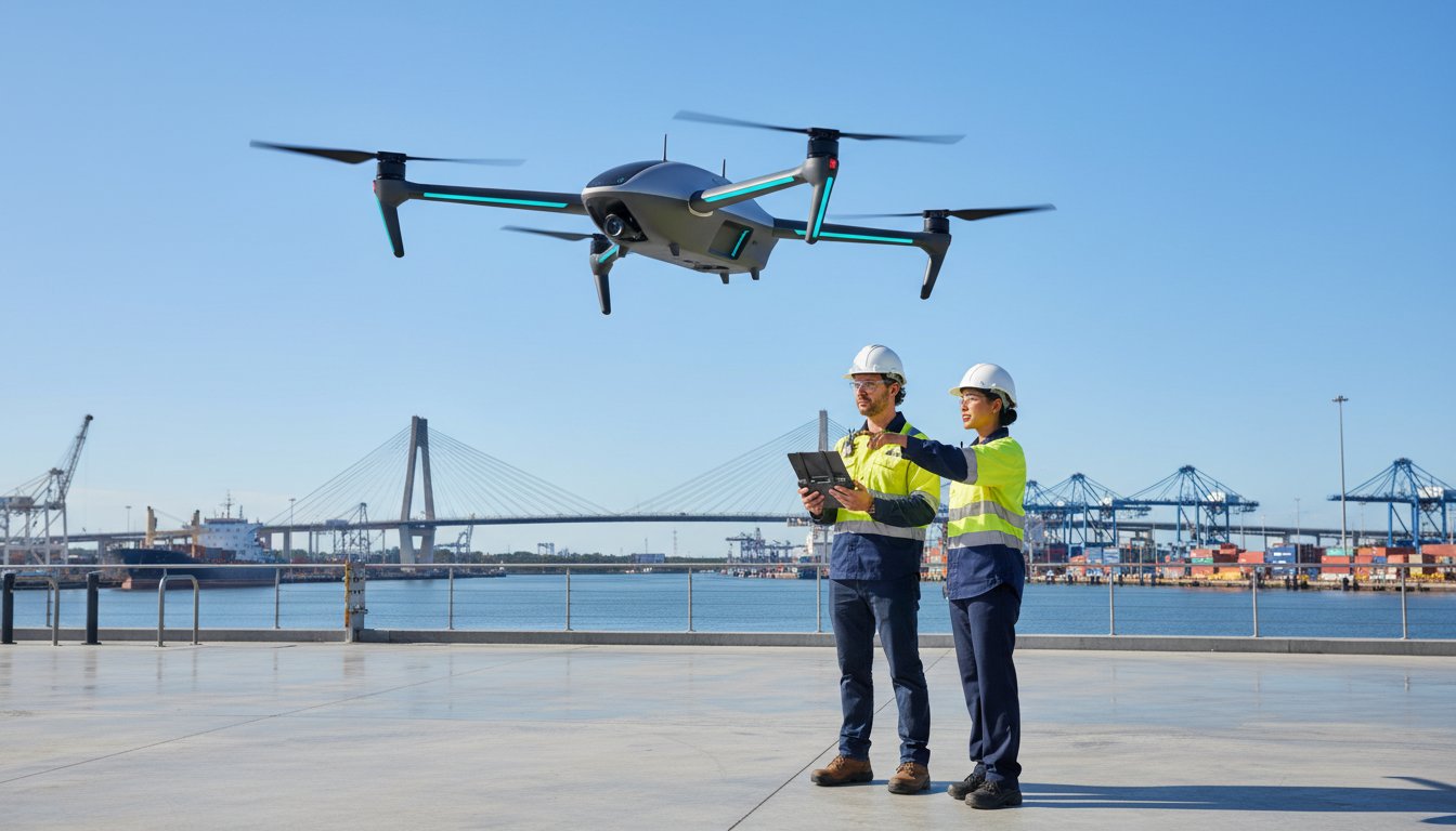
Industrial Applications: Protecting and Inspecting Brisbane Assets
Brisbane’s heavy industries face unique challenges, from high-density urban construction to remote regional operations. Integrating an unmanned aerial vehicle into standard workflows allows for a level of oversight previously restricted by high costs or safety risks. In South East Queensland, these systems facilitate high-detail inspections of bridges, power lines, and telecommunication towers without requiring technicians to work at heights. This shift reduces site downtime by up to 40% in some infrastructure projects.
For the mining and construction sectors, UAVs provide 98% accuracy in volumetric measurements for stockpiles, replacing manual ground-based surveys that often take days to complete. Environmental monitoring also benefits from this technology. Regional Queensland projects use aerial data to assess land use and vegetation health, ensuring compliance with strict state environmental regulations. By combining aerial views with existing CCTV installation Brisbane projects, site managers create a comprehensive security and operational net that covers every corner of their asset.
Aerial Asset Protection
Large industrial yards often struggle with blind spots that ground cameras can’t reach. UAVs provide a rapid response mechanism to perimeter alarms, often arriving at a breach site five times faster than a traditional vehicle patrol. This capability complements the work of leading security firms Brisbane wide, providing an “eye in the sky” that identifies threats before they escalate. Thermal patrols are particularly effective for detecting heat signatures of intruders in unlit, high-risk areas, ensuring that security remains tight even in total darkness.
Surveying and Mapping
Traditional surveying methods often stall project timelines. Using an unmanned aerial vehicle reduces data collection time from weeks to hours for Brisbane developers. This speed enables the creation of digital twins for physical assets, which are essential for long-term maintenance planning. By integrating this aerial data directly into existing Geographic Information Systems (GIS), project managers maintain a live, accurate record of site progress. This ensures that every stakeholder, from the boardroom to the site office, works from the same set of high-resolution data.
Navigating Australian UAV Regulations: CASA Compliance
Operating an unmanned aerial vehicle in Queensland requires more than just technical skill; it demands a strict adherence to the Civil Aviation Safety Authority (CASA) framework. Brisbane features some of the most congested airspace in the country. This makes compliance a non-negotiable safety priority for any project manager. CASA classifies operations into two main streams: the “Excluded Category” for sub-2kg drones and the Remote Operator Certificate (ReOC) for professional entities.
- Standard Operating Conditions: Flights must stay below 120 metres, remain within Visual Line of Sight (VLOS), and keep at least 30 metres away from people.
- ReOC Advantages: Holding a ReOC allows businesses to apply for specific exemptions, such as flying at night or within restricted zones that are strictly off-limits to hobbyists.
Local firms often find that managing these legalities internally is a resource drain. This is why many tier-one contractors prioritise licensed drone hire to offload the regulatory burden and manage corporate liability effectively. Using a certified partner ensures that every flight is logged, every pilot is qualified, and every mission meets federal safety standards.
Restricted Airspace in Brisbane
Brisbane’s geography presents unique challenges for an unmanned aerial vehicle pilot. Major hubs like Brisbane Airport and Archerfield Airport have 5.5km exclusion zones that require specific CASA permissions for commercial work. Beyond the airports, flying over public infrastructure or private property involves strict privacy considerations. Under Queensland law, capturing data without consent can lead to civil litigation. Professional operators manage these permissions as part of their pre-flight mobilization, ensuring every byte of data is collected legally. Understanding the full scope of CASA drone rules for Brisbane operations is essential for any business seeking to avoid fines and maintain project momentum.
Risk Management and Insurance
Safety-first operations rely on a Job Safety Environmental Analysis (JSEA) for every deployment. This document identifies hazards like high-voltage power lines or high-wind corridors common in the Brisbane River valley. In the Australian industrial sector, professional certification is the only way to guarantee the pilot is covered by comprehensive public liability insurance. Most commercial sites require a minimum of A$10 million in coverage. Without a certified partner, a business assumes the full financial risk of any mid-air incident or property damage. Professional UAV services provide the boots on the ground reliability needed to protect your assets and your reputation.
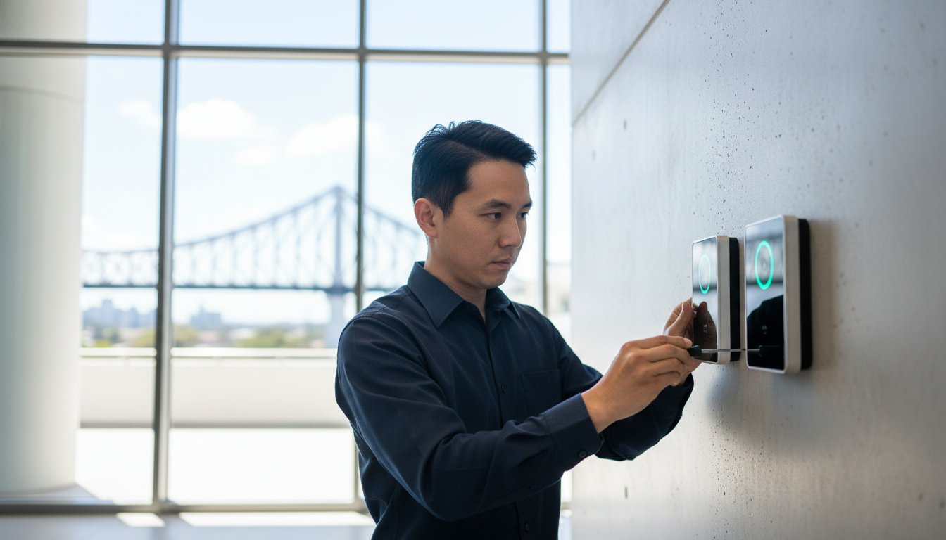
Integrating UAVs into Your Brisbane Security Strategy
Treating an unmanned aerial vehicle as a simple gadget is a mistake for any serious Brisbane operation. To get real value, you need an “Asset-First” approach. This means viewing the data captured by the drone as a critical business resource, just like your fuel supplies or heavy machinery. When you prioritize intelligence, you stop reacting to problems and start preventing them. Transitioning from reactive maintenance to proactive aerial monitoring allows site managers to spot perimeter weaknesses or structural fatigue before they turn into costly downtime or safety incidents.
Brisbane firms often face a choice: build an in-house drone program or outsource to professionals. An in-house setup requires significant investment in ReOC (Remote Operator’s Certificate) compliance, pilot training, and constant hardware updates. For many, outsourcing is the pragmatic path. It provides immediate access to specialized sensors like thermal imaging and LiDAR without the heavy capital expenditure. Looking ahead, the future of the unmanned aerial vehicle in Queensland is tied to 5G connectivity. This tech enables real-time, low-latency data streaming across expansive sites. We’re also seeing the rise of “Drone-in-a-Box” solutions, where autonomous units live in weather-proof docks on-site, deploying automatically for scheduled patrols without needing a pilot to travel to the location.
The Asset Resources Group Advantage
We bridge the gap between traditional physical security and modern aerial intelligence. Our team doesn’t just fly drones; we integrate them into your existing security ecosystem. We tailor every mission to complement your current alarms and access control systems, ensuring there are no blind spots in your perimeter. You won’t just get a folder of raw footage. We provide professional data reporting that site managers actually use to make informed decisions about site safety and resource allocation.
Getting Started with Aerial Inspections
Start with a comprehensive site audit to identify high-value opportunities where drones can replace high-risk manual tasks. It’s vital to set clear KPIs for your data collection, such as the speed of incident response or the accuracy of stockpile volume measurements. Deploying an unmanned aerial vehicle for high-access structural inspections typically reduces operational costs by over 75% compared to the significant labor and time required for traditional scaffolding installations.
- Identify: Pinpoint high-risk zones that are difficult for ground patrols to reach.
- Analyze: Use thermal overlays to detect equipment overheating or electrical faults.
- Action: Use weekly aerial reports to update project timelines and site maps.
Future-Proofing Your Brisbane Asset Management
Deploying an unmanned aerial vehicle isn’t just about high-tech hardware; it’s about securing a competitive edge in Brisbane’s demanding industrial landscape. From the Port of Brisbane to the Surat Basin, site managers are using these tools to reduce inspection times by up to 50% compared to traditional scaffolding or rope access methods. You’ve seen how modern sensor payloads and strict adherence to CASA Part 101 regulations ensure that data collection remains both safe and precise.
Asset Resources brings a pragmatic, “boots on the ground” perspective to your aerial strategy. We combine specialized industrial sensor payloads with a deep understanding of Queensland’s safety-first culture. Our team bridges the gap between complex drone technology and integrated security and asset management expertise. We don’t just fly; we deliver actionable insights that protect your people and your bottom line. Since our operations are fully CASA-compliant, you can trust that every flight meets the highest Australian standards for risk mitigation.
Ready to streamline your maintenance schedule? Request a Professional Drone Asset Inspection Quote from our expert team today. Let’s get your project moving with the reliability your site deserves.
Frequently Asked Questions
What is the difference between a UAV and a drone?
A drone and an unmanned aerial vehicle are essentially the same thing, though “UAV” is the preferred term in industrial and regulatory contexts. While “drone” often refers to recreational quadcopters, an unmanned aerial vehicle typically describes the entire system used for professional data collection and asset management. CASA uses these technical terms to define aircraft that operate without an onboard pilot, focusing on the sophisticated technology required for commercial mobilization.
Do I need a licence to fly a UAV for my Brisbane business?
You need a Remote Pilot Licence (RePL) if you intend to fly an aircraft weighing more than 2kg for commercial purposes in Brisbane. For very small drones under 2kg, you must still register the aircraft with CASA and follow standard operating rules. Businesses must also hold a Remote Operator’s Certificate (ReOC) to ensure full regulatory compliance and insurance coverage for high-stakes industrial projects.
How high can a commercial UAV fly in Australia?
Commercial UAVs are restricted to a maximum altitude of 120 metres above ground level across Australia. This limit is strictly enforced by CASA to prevent interference with manned aviation, particularly near Brisbane Airport or Archerfield. If your project requires higher flight paths for specific asset inspections, you must apply for a formal flight authorization or specialized permit from the regulator.
Can UAVs be used for security surveillance at night?
UAVs can be used for night surveillance provided the operator holds a specific CASA approval for After Dark operations. Using thermal imaging payloads allows security teams to monitor large industrial sites or construction zones with high precision. Operators must maintain a visual line of sight or utilize advanced sensor technology to ensure the safety and quality of the surveillance mission during low-light hours.
What happens if a UAV flies over my private Brisbane property?
Privacy laws and CASA safety regulations dictate that a pilot must not fly within 30 metres of people not involved in the operation. While flying over private property isn’t always illegal, the Privacy Act 1988 governs how data and images are collected. Property owners can report safety breaches to CASA or seek legal advice if they believe an unmanned aerial vehicle is causing a nuisance or breaching surveillance legislation.
How much does a professional UAV asset inspection cost?
Professional UAV asset inspection costs vary based on the complexity of the site and the sensors required. Industry data indicates that basic structural surveys often start around A$1,500 per day, while specialized LiDAR or thermal mapping can exceed A$3,500 per day. These rates typically include the pilot’s labor, equipment mobilization, and the final data processing required for a comprehensive technical report.
Are UAVs safe to use around high-voltage power lines?
UAVs are safe and highly effective for inspecting high-voltage power lines and commercial solar installations when equipped with electromagnetic interference shielding. For businesses looking to enhance their energy efficiency through expert solar services, click here. Using long-range zoom lenses allows pilots to maintain a safe stand-off distance, preventing the aircraft from entering the high-energy field. This approach prioritizes safety first, reducing the risk to human workers who would otherwise need to climb towers or use manned helicopters.
How does weather in South East Queensland affect UAV operations?
South East Queensland weather poses specific challenges, particularly during the summer storm season from November to March. High temperatures can cause battery degradation; meanwhile, wind gusts exceeding 35 km/h generally ground most commercial multi-rotor systems. Our teams monitor Bureau of Meteorology data closely to ensure mobilization occurs during stable windows, maintaining operational integrity and protecting hardware from sudden tropical downpours.